|
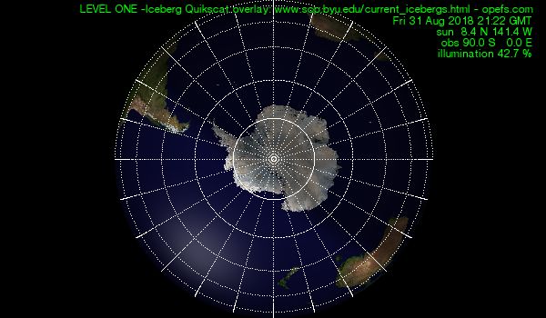
Iceberg
Quikscat Display
of large Antarctic icebergs
Hot-linked
Antarctic research stations are displayed on
LEVEL THREE.
(It is possible to click on the station symbols to go to their respective
webpages.)
The
location of the icebergs from Quikscat data is shown by a green square.
Icebergs
above a latitude 62 Degrees have been specially marked and are displayed
with full coordinates. The size of the icebergs is not to scale.
Antarctic research stations are displayed on LEVEL THREE. It is possible
to click on the station symbols to go to their respective webpages.
The
data displayed here are from http://www.scp.byu.edu/current_icebergs.html
and
are typically updated once or twice a week, typically on Mondays and
Fridays. Positions reported here are extracted from near real-time
QuikSCAT data.
Positions reported in the full scientific iceberg database are generated
from science data and have been more accurately tracked. The full
database is updated only a few times per year.
This
display cannot possibly contain all potentially hazardous icebergs
in Antarctic waters -- QuikSCAT was designed for measuring ocean
winds, not icebergs. QuikSCAT's serrindipitous utility for iceberg
tracking has proven useful, but is not perfect: Smaller bergs (less
than 5 km) cannot be reliably tracked and loss of contrast due to
surface melting can result in loss of track for larger icebergs.
Further, as the SCP team is not an operational agency, errors are
expected and cannot be held responsible for omissions or errors.
Also note that the large icebergs tracked here tend to shed smaller
iceberg fragments which are serious navigation hazards in nearby
areas. Fragments (large and small) can drift substantial distances
from their origins.
What
am I looking at?
The Explanation Page will
give a guided tour.
|
 This
work is licensed under a
Creative
Commons Attribution-NonCommercial-ShareAlike 2.0 Germany License.
This
work is licensed under a
Creative
Commons Attribution-NonCommercial-ShareAlike 2.0 Germany License.